Elder Scrolls Lore » Discussions
Scale of Tamriel and Skyrim along with Traveling Times.
-
6 people like this
-

How large is Skyrim? Tamriel? In the game? In the lore?
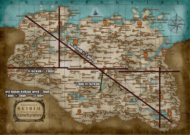
In the game the longest diagonal is 3.5 mi +/-0.5 mi depending on the source. Below is one from Matt Sutton
The game is a very condensed form of the Skyrim from lore for obvious development and technology reasons. A long time ago (2005) Arthmodeus and Prometheus made a scaled map of Tamriel. I believe they used Daggerfall's data, but I didn't find anything on their method. I used their map and scaled a common game map to match (with AutoCAD, lol)
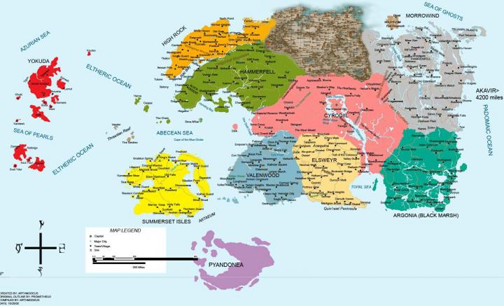
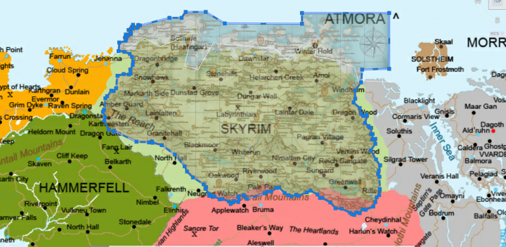
The diagonal across the main continent is about 1,500 mi, which is a bit further than the distance from Vancouver, BC, Canada to Tijuana, Mexico. The diagonal across Skyrim is about 550 mi. Below is an overlay of Skyrim from the two time periods; I just found it interesting seeing how the cities and borders changed.
Next I mapped the routes between Skyrim's capitals, for reference the distance between New York and Boston is 216 mi:
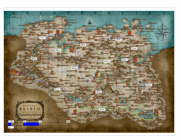
For a country with full sized cities with rural villages in between, these distances are reasonable. However these distances are over 150X that of the game. If you're writing a story based on gameplay, it will be difficult to incorporate the difference. I have opted to use a 1/10th scale of this map; this puts most cities a one or two day walk away, which still allows common folk to visit and trade between cities fairly easily.
How far can you walk in a day? I compiled a list of average travel distances:
Foot Travel:
Avg. walk speed: 3mi/hr (5km/hr)
Marching distance level: 20 mi/day (32.2km/day)
Marching distance hilly: 14 mi/day (32.2km/day)
Marching distance mountainous: 9 mi/day (32.2km/day)*Party size, fitness, weather, pack weight, and setting camp all affect distances.
Horse Travel:
On Roads / trails:
Level or rolling terrain: 40 mi (65 km)
Hilly terrain: 30 mi (48 km)
Mountainous terrain: 20 mi (32.2km)Off-Road (or unkempt trails etc):
Level/rolling grasslands: 30 mi (48 km)
Hilly grasslands: 25 mi (40 km)
Level/rolling forest/thick scrub: 20 mi (32.2km)
Very hilly forest/thick scrub: 15 mi ( 25km)Un-blazed Mountain passes: 10 mi (16 km)
Marshland: 10 mi (16 km)*Divide by ~2 for heavily laden horses (knight wearing armor, cart)
**Endurance horses can go ~2x further
***Using multiple horses can greatly increase distance (Mongolians/ Pony Express)
*Assuming good weatherHow far a horse travels in one day
Source: http://www.cartographersguild.com/showthread.php?t=19730Sail Travel:
Favorable winds: 4-6 knots (4.6 – 7 mph / 7.4 - 11 kph)
Poor winds: 1.5-2.5 knots (1.7 – 2.9 mph / 2.8 – 4.6 kph)
Overall Avg.: 80 – 120 mi/day (130 – 160 km/day) traveling through the night.Speed Under Sail of Ancient Ships
http://penelope.uchicago.edu/Thayer/E/Journals/TAPA/82/Speed_under_Sail_of_Ancient_Ships*.htmlLeave a comment if you have any suggestions to add.
-
 This is awesome. Unfortunately, it's too late for me to really incorporate this into Straag Rod without seriously breaking some story elements. I do allow more time for travel, but lol, with the way I detail everything, do we really want me adjusting travel times. Part 17 of Book 1, 234 pages, from Whiterun to Dawnstar Part 34 of lol, can't even finish. This is great though. Wish I had thought of it, to be honest, as I know my timeframes are screwy, but, can't have everything.
 -

You know this is impeccable timing for me. I was just going to ask tonight about sail times as I remembered we all discussed it a while back.
For the story I’m currently writing, I was hoping to work out the distance by boat from Blackmarsh to Ebonheart.
Thanks to this I now know the distance is roughly 1300 Nautical miles.
Using your system.
Sail Travel:
Favorable winds: 4-6 knots (4.6 – 7 mph / 7.4 - 11 kph)
Poor winds: 1.5-2.5 knots (1.7 – 2.9 mph / 2.8 – 4.6 kph)
Overall Avg.: 80 – 120 mi/day (130 – 160 km/day) traveling through the night.I now can say with some degree to accuracy that the journey will take approximately two weeks. Perfect...
Well done for putting this together Exuro.
-
-
-
-
-

-

Dopeness. Pure dopeness. I tried using a lore book that said Helgen to Lake Ilinalta was half a day's ride and found it hard to extrapolate the nature of the ride that was lacking in said lore book and relating centimeters to distance (from the various velocities a horse can travel under certain conditions). This ultimate is dopeness.
Furthermore, according to this individual [link], the measured distance between Betony and the Isle of Balfiera (using Daggerfall's map) is 175 miles. I decided to draw a line from Betony to Balfiera and moved it to Skyrim, starting in Falkreath. To demonstrate the triangle is roughly a 45-45-90 triangle, I — fairly — fitted the cross into a square, arguing that the lines were roughly equal in length as the lines from one corner across another should be equal in length inside a square. Using the Pythagorean Theorem, I found the length to be ~ 124 miles, 248 miles to Riften.
But Riften is 370 miles on the map!
Well, my measurement is not precise. Had I measured the path with all its contortions, the measurement would be higher - Coastline Paradox
Considering the differences of measurement in the video are doubled, a difference of 122 miles does not seem unreasonable.
In short, the distances between the cities might be good rough estimates.

-
 . Sotek, glad it helped. I needed this for some time sensitive coordination coming up in my story.
 This has now been added to the Geography section in The Archives, a shelf which has been gathering dust for a good few years now - it's nice to see a new addition.